Sinking
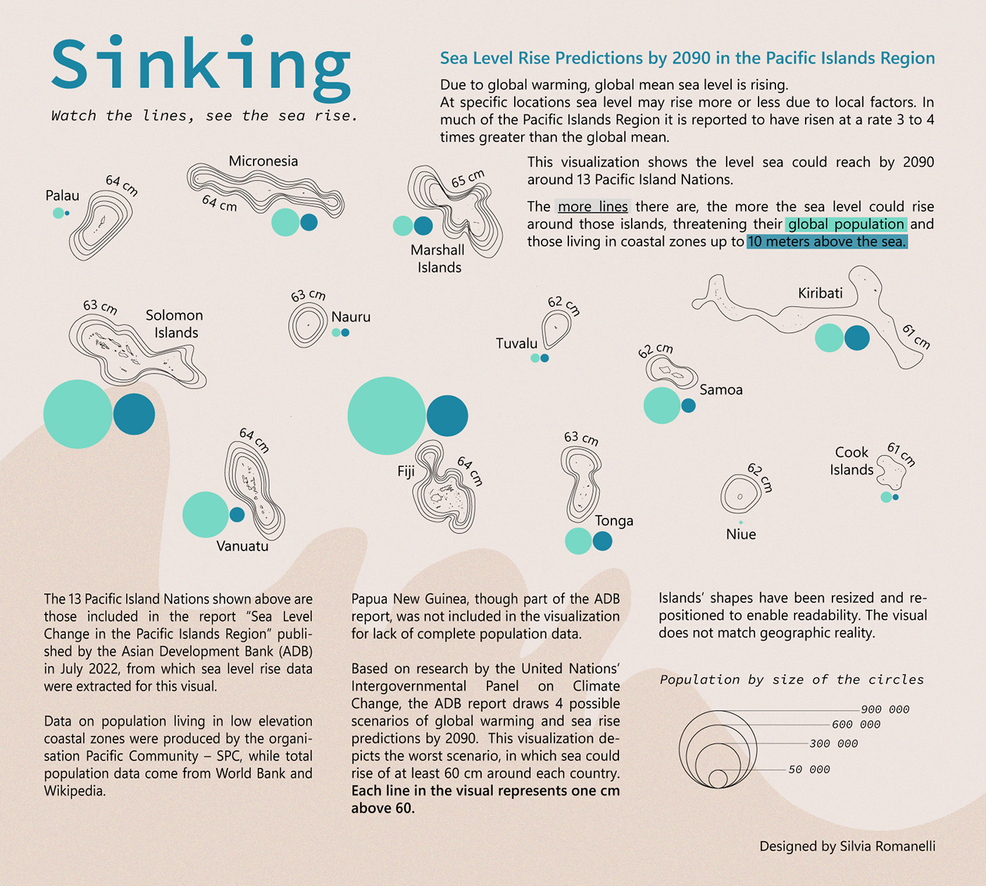
Sea Level Rise Predictions by 2090 in the Pacific Islands Region
In November 2021, the foreign minister of Tuvalu addressed the climate summit COP26 while standing knee-deep in the ocean to raise awareness of the imminent threat sea level rise represents for Pacific islands.
Indeed, changing sea levels can have devastating consequences on the Pacific islands population: coastal flooding, shorelines erosion, infrastructures deterioration… and even the possibility of a portion of their land being under water by the end of the century.
The more vulnerable to sea rising are those living in low-lying coastal lands, which is the majority of the population in many Pacific countries. In Nauru, Tuvalu and the Marshall Islands, at least 85% of the population lives in low-lying coastal zones, up to 10 meters above sea level.
Rising sea level is a direct consequence of global warming. As our planet warms, glaciers melt and more water flows into the oceans. At the same time, as water warms, it expands, making sea level rise.
Global mean sea level has risen about 8–9 inches (21–24 centimeters) since 1880. But sea level rise at specific locations may be more or less than the global average due to local factors. In much of the Pacific Islands Region, sea level is reported to have risen at a rate 3 to 4 times greater than the global mean.
This visualization shows the level the sea could reach by 2090 around 13 Pacific Island Nations, based on research by the United Nations’ Intergovernmental Panel on Climate Change (IPCC). Four possible scenarios are drawn by the IPCC, depending on how much action will be taken against climate change in the coming years. This visualization depicts the worst scenario, in which the sea level could rise at least 60 cm around each country. Each line in the visual represents one cm above 60. The more lines there are, the more the sea level could rise around those islands, threatening their global population and particularly those living in low-lying coastal zones.


Design Choices
The design is inspired by contour lines in topographic maps, though of course lines in this case don’t represent ground elevation or depression, but centimeters sea level could rise in the next seven decades.
I circled the islands of each country and repeated the shape several times to show the sea level increase. Pacific island countries are made up of small islands, sometimes scattered on a great surface of ocean – such as Kiribati – and sometimes counting only one tiny island – as Nauru or Niue do. In order to make them all visible without bigger countries giving a false impression of higher sea rise threat, I decided to resize and reposition each island State in an arrangement that, though not matching geographic reality, enables readability.


As sea could rise of at least 60 cm for each country alike, I decided to show lines only for centimeters above 60 to avoid visual clutter. For population data, I used simple circles with proportional sizes: green for total population and petrol blue for people living in low-lying areas up to 10 meters above sea level. I didn’t write down the absolute values nor the percentages to avoid information overload - I added a size legend instead.


